


By Clint Thompson
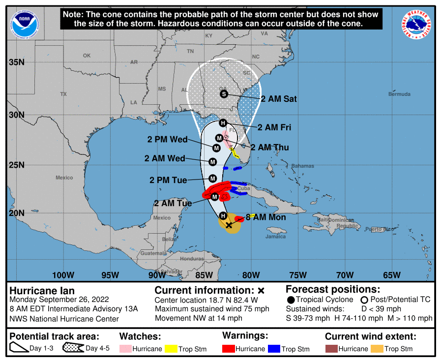
The center of Hurricane Ian is expected to impact the west coast of Florida either Wednesday night or early Thursday morning as a Category 3 before losing some of its steam prior to arriving in Georgia.
Pam Knox, University of Georgia Extension Agricultural Climatologist, provides the latest update on what specialty crop producers should expect in both states.
“Because of the cooler water and being over land and having wind shear overhead, the storm is going to weaken more than they originally thought. It’s still going to be terrible on the west coast of Florida, where depending on exactly where it hits, they could have 10-foot storm surge and winds up to 125 mph. By the time it gets close to Georgia, that’s going to have weakened quite a bit,” Knox said. “We’re likely just to see it as a depression. We’ll still have some gusty winds, but it won’t be as bad. We’ll probably still have quite a bit of rain. I think most of the state is forecasted to get 2 to 4 inches with the exception of the far northwest corner. Folks along the coast could see up to 10 inches in some places, so it’s going to be wet.”
The worst impact, though, is where the storm first makes landfall. The Tampa Bay area is most at risk and why more than 300,000 were issued a mandatory evacuation.
“It’s going to be really critical exactly where it comes on shore. If it comes on shore north of Tampa, then all of that water is going to be driven into the bay. There’s a lot of flat land in Florida there, so that’s going to be a problem,” Knox said. “If it comes in a little south of Tampa, they’re still going to have those 125 mph winds, but they will have maybe a little less storm surge. It’s really critical how it’s going to come in.”
The eastern region of Alabama should receive some rain from the storm this weekend, depending on Ian’s path northward.