


By Pam Knox
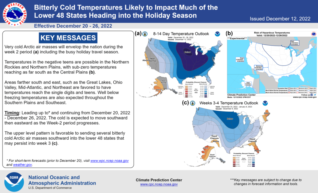
I’m talking about temperature, folks! A lot of my social media feed for the last couple of days has been related to one or more cold outbreaks that could affect the U.S. over the next couple of weeks or even into January. On Twitter, the National Weather Service Climate Prediction Center posted an infographic about bitterly cold conditions likely to occur during the holiday season.
Northern areas of the Southeast region are the most likely to experience the wintry temperatures, but even Florida has above-normal probability. In between, we just don’t know yet — but it is winter and sooner or later cold air is likely to come, even in a La Nina year.
Anything that is more than a week out is just showing the general pattern, and you cannot trust the forecasts to give you believable actual temperatures, no matter how many times someone posts a map on Twitter.

For the next couple of weeks and to the end of the year, we can expect some bitter cold following last week’s rain event. It looks like even lower temperatures are likely over the Christmas holiday for a lot of the country, although we don’t know yet exactly how low those temperatures will be in the Southeast.
I think it is likely that freezing temperatures will get down into Florida in the second outbreak. This is different than last year when parts of southern Georgia did not see a freeze until well into January. This is good news for farmers there, because if it happens, it will kill off a lot of pests and the vegetation that harbors them.
Looking farther ahead, there are some signs that a sudden stratospheric warming is starting to occur over the North Pole. The last time that happened, in 2021, Texas had a huge cold outbreak with significant impacts in February. That means there is a good chance of the polar vortex weakening and bringing cold air depending on how it shapes up.
All we can say at this time is that if the sudden stratospheric warming occurs, we are likely to see impacts in about mid-January, since it usually takes about 30 days for the vortex to react. Some region is likely to get cold then, but it could be Texas again, or it could be Europe, or somewhere else entirely. That includes us, but since this is no more than wild speculation at this point, keep watching your local forecasts for more updated information. As you get closer to real-time, the forecasts will be better, and you will have more detailed predictions about the timing for when the coldest air will come and how cold it will really get.
Will we get snow? Well, that depends on the weather. Snow is tricky to predict because it depends on the depth of the cold air, when and where that air goes, whether there is moisture at the same time to produce the snow, and whether or not you wish hard enough — just kidding about that last part! I think it is likely that some people in the Southeast will see snow, especially at more northern locations and at higher elevations, but when and where that will occur is too soon to know. All I will say is that the pattern is promising for some of us to see some flakes.
Whether you are traveling for the holidays, have pets or livestock, or grow crops like strawberries, use these tips to prepare for the cold. To stay up-to-date on climate and agriculture in the Southeast, visit extension.uga.edu/climate and subscribe to the University of Georgia Climate list.
Pam Knox is the director of the University of Georgia Weather Network and serves as an agricultural climatologist with the Department of Crop and Soil Sciences.